New Zealand: 17. Mount Cook and Christchurch

“Will we see Mount Cook?” lots of the travellers were asking. “When will we see Mount Cook?”

“There’s a good chance,” Denis replied. “We could get lucky.”

Apparently, this isn’t the case with every tourist group. It’s all too easy for low cloud or any poor visibility to hide the highest peak in New Zealand so completely that it’s invisible even (especially?) from just a few miles away.

Mount Cook

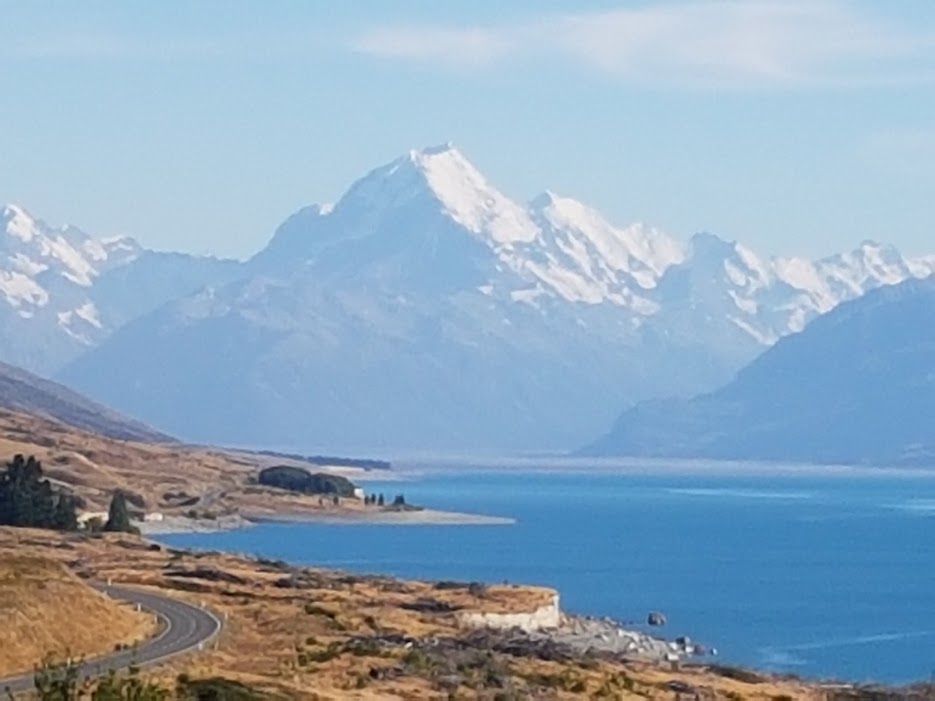
We did get lucky. As we drove along the shore of Lake Pukaki, we had splendid views of Mount Cook which grew bigger and bigger as we got nearer. We stopped at the Hermitage Hotel for a morning break, with excellent views from the cafe terrace. Then back to the coach, past Lake Pukaki and on to Lake Tekapo for what is apparently an obligatory stop at the Church of the Good Shepherd. It’s a picturesque little stone building in a beautiful location: the east window of clear glass looks out over the lake to the mountains beyond. It’s supposed to be a place of prayer and worship, reminding people of the original settlers of this land, but also of the glory of God. Somehow I couldn’t get beyond the tourist rip-off factor. An attendant abruptly reminds you that no photography is allowed – unless you’re a professional photographer, when you will be allowed a 30-minute shoot for a mere $100. Hmm. Crowds of camera-wielding visitors can indeed detract from the holy feeling of a place. But not as much as what feels like an exaggerated commercialism.

The road then took us through the Mackenzie Country, then over Burke’s Pass, stopping at Geraldine for lunch, where we found the congregation of St Mary’s church sharing a church lunch, and happy to greet us. Then on, on, on over the Canterbury Plains, and so at last to Christchurch again.

Here we at last managed to make a short visit to the Transitional (AKA ‘Cardboard’) Cathedral

20180128_160650

They were getting ready for a service to mark the beginning of a new school year, for which children and parents were gathering, so we had only a few minutes to look around and take a couple of photographs.

20180128_161506

Behind the Cathedral is the memorial to the 185 victims of the 2011 earthquake, a moving sight which includes baby seats and wheelchairs representing the children and disabled who lost their lives.

20180128_161810

Other notable views of Christchurch included the ruined original Cathedral. There’s been a lot of debate about whether to build a completely new, 21st century cathedral, or to rebuild the much-loved Victorian building. It seems the conservationists have won out over those (including the Bishop) who wanted something more appropriate for contemporary worship and witness.

20180128_164712

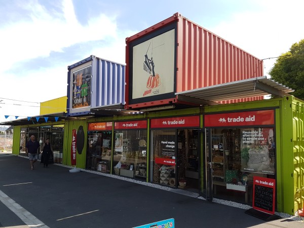
And the Container Mall, where colourful shipping containers were brought in as soon as possible after the earthquake, to get the city’s commercial and business life up and running again. It’s such a feature, that as some of the shops return to rebuilt premises, other businesses are starting up in the vacated containers. I wouldn’t however recommend the container public toilets… in temperatures that were still in the upper 30s Celsius, these were not a comfortable experience.

20180128_170232

Even though we spent so few hours there, we loved Christchurch, reputedly the most English of New Zealand cities. And so the last day of our New Zealand holiday drew to an end.


New Zealand: 16. We stand on the Misty Mountains

The next day was the hottest day so far, with temperatures reaching 37° C. This is supposedly unheard of in those parts of South Island: I’ve already mentioned that the hotels down there don’t have air conditioning, on the grounds that they don’t need it.

And we finally got our promised helicopter flight, from Queenstown Airport to the top of the Remarkables. I wasn’t the only member of the group who had been feeling some trepidation about this, even though (very fortunately) it was the day before four British tourists were killed in a helicopter crash at the Grand Canyon, and not the day after… But it was actually a great experience. A short one – which is probably also a blessing.

enter image description here

The thing that surprised me was that it didn’t feel like we were travelling fast, though it only took a few minutes before we were landing at the top. Yes, there was a slight moment of “Aargh! There’s a mountain side just a few yards to our right…” And here we are:

enter image description here

Enjoying spectacular and beautiful views of Queenstown and Lake Wakatipu

View of Queenstown and Lake Wakatipu

Safely back on land and boarded the coach, we continued to Arrowtown, a quaint old gold-mining town, near the river where I had tried my hand at panning for gold a couple of days earlier. It feels like some kind of old cowboy town, with its old-style clapboard houses and street furniture.

Arrowtown Post Office

Arrowtown post box

After lunch we had another long drive on to the Kawarau Gorge, Cromwell and the Lindis Pass – at 965 m above sea level, the highest road we drove over in New Zealand, and so on to the junction town of Omarama, where we were to spend the night at the Heritage Gateway Hotel. There weren’t many places to eat in town (it’s not much of a town) so we all ate together in the hotel restaurant. It was good to share a more communal meal, which hadn’t been a frequent event during our stay. It was also a pleasant summer evening to sit outside with pre- or post-mealtime drinks. Some of our fellow-travellers stayed up to see the stars of the southern hemisphere, including the Southern Cross. I didn’t manage it: after all the early starts and long coach rides I couldn’t stay awake long enough, especially as it didn’t get dark until very late.

Shame. It would’ve been quite a sight.

stars of the southern hemisphere

Written with StackEdit.

New Zealand: 15. Fjord and cave

The next day was another long day on the road which left us feeling tired and irritable. But what a day! An early start meant getting up at 0530 in order to leave the hotel at 0700 for the drive along the Eglinton Valley, and stopping briefly at aptly-named Mirror Lake, to our chief destination at Milford Sound in New Zealand’s glacier-carved Fjordland. Our Lonely Planet guide tells us that “the world-beating collage of waterfalls, verdant cliffs and peaks, and dark cobalt waters is at its best” on a clear, sunny day. “More likely, though, is the classic Fjordland combination of mist and drizzle, with the iconic profile of Mitre Peak revealed slowly through shimmering sheets of precipitation.” Well, we were the lucky ones: the weather was near perfect.

Milford Sound on a perfect day

Lots and lots of photographs as the boat took us along the fjord and as far as the open sea, which we gazed upon, turned about, and returned into the calmer waters of the Sound. Captain Cook never actually discovered it, because his view from out at sea didn’t show it as a inlet at all. He just sailed on by, and missed a treat. “The fjord remained undiscovered by Europeans until Captain John Grono discovered it c.1812 and named it Milford Haven after his homeland in Wales. Captain John Lort Stokes later renamed it Milford Sound. (Source: Wikipedia)

Milford Sound

Apart from the scenery, there were also glimpses of basking seals.

basking seals

This is Alison’s picture. She was convinced that the bird in the background was a penguin. Me, I think it was just one of the seals getting dressed for a fancy dress party.

From Milford Sound, it was south again to the most southerly of all our overnight stays in New Zealand: Te Anau. Here’s where I faced and didn’t exactly overcome, but at least survived, one of my worst phobias. Alison really really wanted to visit the world-renowned glowworm caves. I thought I could do without. I do not like caves. I do not like them, Sam I Am. Perhaps it comes of reading Tom Sawyer as a child – those nightmare chapters in which Tom and Becky get separated from everyone else and are lost in the caves, and become convinced they’re going to die, and when they do eventually see a fellow-human being, it’s the terrifying Injun Joe… It’s the darkness, the sense of millions of tons of rock over your head… And don’t even get me started on the thought of potholing, and the crawling through narrow tunnels not even on hands and knees…

(Quick break till I stop hyper-ventilating and the panic ebbs away…)

But in the end I went because Alison wanted me to, and she wanted to see the caves so much. It was worth a visit. But it was terrifying too: the noise of the rushing water, the walkways over drops into the abyss. Strangely enough, the glowworm part wasn’t alarming at all, even though it involved getting into a small boat on an underground lake (by this time, thankfully, we were away from the rushing of mighty waters), and then being moved along in total darkness by the guide pulling on a rope or wire or something. And then suddenly there are the lights of these strange creatures hanging in the blackness above and around you. It’s like nothing on earth. Naturally you can’t take any flash photos because it scares the poor worms to death, so you’ll either have to go there yourself, or do an image search (try Te Anau glowworm caves) with your favourite search engine. (Incidentally, I am currently using Startpage because it is “the world’s most private search engine”, and it also lets you view images, a feature that Google has just removed.)

I have faced one of my worst fears (-ish) and have survived.

Written with StackEdit.

New Zealand: 14. Lord of the Rings. Etcetera

When we got back from New Zealand, we wanted to watch or re-watch some of the films and TV series set in NZ, to enjoy memories of the places we’ve been. So we started with Top of the Lake on Netflix, filmed in and around Queenstown and Lake Wakatipu.

Let’s just say, it was a Disappointment. New Zealand noir just doesn’t suit our memories of the place. No doubt there are paedophiles, rapists, drug-crazed incestuous hippies, bent coppers, murderers, and gangsters in New Zealand. But thankfully we didn’t see them; and the country also prides itself on having relatively little crime. But apart from the crime, we couldn’t make much sense of the characterisation and motivation in the story. One minute people are having a violent showdown; the next they’re somewhere else entirely, and behaving as if nothing has happened. One minute they’re fighting and saying it’s all over between them; the next we see them having sex (again). I think there has been a second, more recent, series. We might give it a try, sometime. We’re a bit like Homer Simpson about that. Doh!

In TOTL, Queenstown is described as a “millionaires’ playground”. Which may be true. But it was still a great place for lots of other people who aren’t millionaires. There was so much to see and do, that our itinerary allowed us a “free day” there, to make our own choice from the smörgåsbord of possibilities. Alison and I had already, the previous evening, enjoyed our first meal in a Vietnamese restaurant – which cheered us up after our gruelling day on the road. On the “free day” we went different ways. Alison chose the Kiwi Birdlife Park, where she actually saw some kiwis in their special nocturnal environment. I opted for one of Nomad Safaris, which was not quite the all-LOTR safari that most of our little group of 5 were hoping for, but was very interesting all the same.

It took in Skippers Road, the “most dangerous road in New Zealand”,
Skippers Road warning

a single track dirt road winding up into the hills, with seemingly impossible passing places and sheer drops to the side. It’s the old road used by the gold prospectors of the New Zealand Gold Rush. One of those rides where you’re willing the driver to keep his eyes on the road, not keep looking round to see how his passengers are enjoying themselves… where you feel yourself automatically leaning away from the cliff edge as if you could stop the landrover from falling off the road…

It also took us to Arrowtown, one of the old gold rush towns, and to the Arrow River to try our own hand at panning for gold. Me, I didn’t find any. But Paul did: he held his speck of gold like a mote of dust on his fingertip for about 5 minutes before it somehow disappeared. The end of another wonderful fortune. Apparently there are still real nuggets to be found up there. But not very often.

And yes, we did see a couple of places which Marcello the driver claimed had been used as settings in the filming of LOTR. Of course, the whole amazing range of The Remarkables, which feature so often, snow-covered and in summer, as the Misty Mountains. But also, the bend on the Arrow River which had been the Ford of Bruinen, where Frodo escaped from the Black Riders…
The ford of Bruinen
the path near Arrowtown which had represented part of the Gladden Fields…
The Gladden Fields
the place where Aragorn fell in the battle with the Warg Riders… (You have to use your imagination here: it’s the little edge just beyond that clump of trees in the foreground.)
where Aragorn fell

But really, the landscape is so splendid that it’s easy to imagine yourself there in the story. I don’t know how much Peter Jackson has been worth to the New Zealand tourist economy. Much more than his weight in gold, I would think.

After the tour I met up with Alison at the Kiwi Birdlife Park, and we took the Skyline gondola to the top, to enjoy the view of the city, the lake, and the mountains. Selfie!
selfie on the skyline gondola

And in the evening, another of Queenstown’s attractions: a cruise on a 100-year old steamship, the TS Earnslaw, which took us to the other side of the lake for an evening meal and a demonstration of sheep-shearing. The excursion includes some olde-time community singing on the way home. Hmm. My old dad would have loved it.

And here’s a thing about South Island. We had saved our warmer clothes, thinking it would be cooler when we got this far south. Instead, they were “enjoying” unprecedented temperatures in the high 30s C. Hotels in South Island don’t have air-conditioning: they never need it. So we had a few nights of poor sleep because of the heat. A problem we had not expected.

Written with StackEdit.

New Zealand: 12. Over the Alps and down to the sea

The Tranzalpine is one of the world’s great train journeys, and one of New Zealand’s most exciting, too: from Christchurch on South Island’s east coast, across the Canterbury region, up and over the Southern Alps, and down to Greymouth on the west coast. It was also one of our earliest morning starts: we had to leave the hotel at 0715 to get to the station in time to catch the early train.

The whole journey from Christchurch to Greymouth takes almost 5 hours, but we left the train at Arthur’s Pass to rejoin our coach (which had made the distance in less time) for the westward descent. We had still been able to enjoy the spectacular views from the train as it climbed into the mountains. We even saw snow – though not much of it – on the highest peaks.
Leaving the Tranzalpine at Arthur's Pass

The descent by road was one of the steepest gradients I’ve ever been driven down, and I was happy not to be the driver, especially of a coach full of 51 people and their luggage. Our first stop was at Hokitika, now a small coastal town, but in the 1860s it was a bustling gold rush town, filled with prospectors from all over the world who had come to the west coast to make their fortunes. Eleanor Catton’s Man Booker Prize-winning novel The Luminaries is a fascinating mystery that also gives a picture of the town and the period.

Hokitika today is a centre for the traditional greenstone industry, but its major industry now is tourism. We had the best lunch here of any of our NZ travels, at the Aurora Restaurant where we shared a grilled chicken open sandwich – freshly prepared! unlike many of the plastic-wrapped lunchtime sandwiches we had eaten on other days – and some Bundaberg ginger beer.

After lunch our journey took us onward down the west coast highway to Franz Josef. Here we made our first unsuccessful attempt to get a helicopter ride to take us up onto the Franz Josef Glacier. First you have to be weighed so they can select a passenger manifest of the right total weight, and distribution in the helicopter. Then we even got as far as being allocated to groups, given wrist bands and taken through the safety instructions (main point: Always approach the helicopter from the front; never go anywhere near the tail end. Anyone who’s ever watched ER won’t need telling…) We were led out of the office and halfway across the road to the landing site, before the message came through that flights were cancelled because of poor visibility.

There’s not much else to see at Franz Josef, and not too many eating places (though a few more than Denis let on about…) so the whole party ate at The Landing.

Written with StackEdit.

New Zealand: 11. A first look at Christchurch

Leaving Nelson on Monday morning (bags out at 0700, depart at 0800) we began one of our longest days on the road, travelling down to Christchurch. Christchurch is almost directly south of Nelson, but since the 2016 Kaikoura Earthquake (the second largest earthquake in New Zealand since European settlement began) it’s impossible to take the SH1 highway down the east coast. Instead we had to set off south-west on SH6, then south on SH65 through Victoria Forest Park, then south-east on SH7 before rejoining SH1 at Waipara. It’s a total distance of over 420 km, which Google Maps reckons takes 5 hours 13 minutes, but I guess that would be by car rather than in a 53-seater coach. Much of this route is not designed for the heavy traffic that has been forced to take this diversion since the earthquake, so there were many twists and turns and roadworks along the way.

Although we had various photo stops to look at the view, I didn’t take many photos. Here are some trees, mountains and clouds,

Somewhere on the road to Christchurch

and here is one of the many ‘braided rivers’ that are so characteristic of New Zealand’s landscape.

Braided river

It’s the kind of place I imagined seeing the refugees from Rohan crossing. Instead, there’s just a big orange digger out there in the distance.

When we reached Christchurch, everyone was a bit tired and crotchety. But Alison and I were very keen to try and get into the city centre and have a look at the ‘cardboard cathedral’ which we had heard about when Bishop Victoria spoke to the Oxford Diocesan Clergy Conference in 2014. We knew that we were scheduled to return to Christchurch later in the tour, but we weren’t entirely confident about how much the itinerary at that point might allow us to see. So we decided to walk into the city centre – which turned out to be 4.9 km, and took about an hour. It wasn’t helped by the fact that, as we neared the city centre, there were more and more road closures and diversions where work was still going on to demolish, repair and rebuild in the aftermath of the 2011 Christchurch earthquake. But we found our way to Cathedral Square, where what is left of the original Cathedral stands temporarily derelict.

Christchurch Cathedral in ruins

Then we continued to the site of the transitional cathedral AKA cardboard cathedral. We had hoped it would still be open – the guidebook we had looked at said it was open till 7 p.m. in the summer. The guidebook was wrong! It closed at 5 p.m., and the custodian had just set the alarms and locked up.

Christchurch Transitional Cathedral

Ever since 2011 there have been heated discussions about what to do with the old Cathedral. We got the impression from Bishop Victoria that she might have been of the party which wanted to demolish it completely and build something new. But the heritage faction, who wanted to rebuild the old Cathedral exactly as it was (it is, after all, 130 years old!) appears to have won the day. Perhaps if the original Cathedral had been more thoroughly destroyed they might have been able to do something like in Coventry? – building a modern cathedral alongside the ruins of the old, as a reminder of… well, in this case, the forces of Nature, perhaps?

The custodian gave us a lift part of the way back to the hotel, for which we were very grateful after the long day of travelling.

Written with StackEdit.

New Zealand: 10. A second day in Marlborough and Nelson

Almost as soon as we set foot on South Island, waiters and other people, when they heard we’d just come from the North, began asking us, “So, which do you like best? North Island or South Island?” The answer we came to give, more and more (so that we might appear to have given it some serious and measured thought) was something along the lines of, “North Island for the history, and the Maori culture; South Island for the scenery.” But in truth, now that we’re home, I would probably say much more unequivocally, South Island.

(Oh, I don’t know though. What about Auckland? and the the Bay of Islands? and Napier? So maybe the jury is still out, after all.)

But South Island! Which is often called (by South Islanders!) “the mainland”. It is, quite simply, stunning. Almost beyond belief.

On the first morning we woke up in Nelson, the coach took us north along the coast of Tasman Bay, to the town of Kaiteriteri. This is the place of embarkation for the boat cruise up into Abel Tasman National Park. Suzanne had warned us that the boat operators were fairly laid-back and disorganised about which boat ticket-holders were supposed to embark on, and this turned out to be the case. I think we finally boarded from the third queue we had joined. Having watched the film Dunkirk on the flight to Singapore, I was used to the idea of lining up on a sandy beach to climb a gangplank onto a small vessel. But was relieved that we were not being strafed by Stukas while we were waiting.

Some of our party opted to be put ashore at Apple Tree Bay and walk 7 km through the park to be picked up again by the boat at Anchorage. But it was such a hot sunny day that Alison felt the heat would prove too much, so we decided to stay aboard and enjoy the ride. There was a sense in which both choices were wrong. Yes, we didn’t get sun- or heat-stroke aboard the boat; but the view of most of the coast was just rocks and trees. While for those who took the walk, most of their way was in the shade of the trees; but they didn’t get too great a view either.

But on the other hand, though rocks and trees may start to look a bit samey, you also get spectacular views of little islands, huge skies and distant mountains:

Abel Tasman Bay

The most-photographed rock in the National Park (possibly in the whole of New Zealand) is Split Apple Rock

Split Apple Rock

It’s a huge round piece of granite, which looks like an apple that’s been sliced in half. Natural forces are awesome1, aren’t they?

We returned to Nelson in the early afternoon with the rest of the day free to explore on our own. Nelson is an attractive little city, famous for being the place where the first game of rugby in New Zealand was played, in 1870, and for being the Centre of New Zealand (allegedly, or possibly. Or maybe not.) As well as being the place where the One Ring to rule them all was really made. For the film at least.

A word of wisdom about walking to the Centre of New Zealand. It is quite a steep climb to get there, and we were climbing it on a very hot sunny afternoon (and had left our water behind because we thought it was only 50 metres away like the sign said2), and were not helped by cheerful kiwis walking the other way and telling us “It’s not that far now!” ‘Not that far’ when you’re walking steeply uphill turns out to be very different from how the same distance feels to the people coming back down.

Part of the view of Nelson from the Centre of New Zealand

Part of the view of Nelson from the Centre of New Zealand

It was in Nelson that we were able to get to our only Sunday service of our stay in New Zealand, which was Evensong at the Cathedral.

Nelson Cathedral

The Cathedral has some PROs: We could find the entrance; and they were actually having an evening service. And some CONs: It has a beautiful labyrinth on the floor, but you couldn’t walk it because it was covered up by a ghastly display of Christmas Trees, which had proved so popular that it had been extended right through January. Evensong was conducted by the Dean, who didn’t seem overly familiar with the Book of Common Prayer: we didn’t have either a psalm or the Collect of the day, because they weren’t printed in the congregational order of service. But he was obviously enjoying himself greatly, and really appreciated our singing.

Dinner in the hotel restaurant, because they had a special offer for guests who ‘ate in’ on Sunday evening. This wasn’t a bad idea for them, in a city where there were so many other great eating places. But the hotel food was pretty good, too.

Written with StackEdit.


  1. We enjoyed the New Zealand use of this awesome word. Quite often used by waiters taking your order: where in this country they might record your order with the words “Great choice!”, we found in New Zealand that “Awesome!” was much more common. Such fun. ↩︎
  2. It was 50 metres from the sign on the corner of the street, to the entrance to the park. ↩︎

New Zealand: 9. Crossing to South Island

North Island to South Island

It was up before 0600 the next morning to leave the hotel at 0730 to catch the ferry to South Island. In the near perfect summer weather we were having, it was a beautiful crossing, leaving the port of Wellington and sailing the 92 km over the Cook Strait and along the Marlborough Sound to Picton.

Leaving Wellington Harbour

Leaving Wellington Harbour

And this is why it’s called Aotearoa: the land of the long white cloud:

enter image description here

From Picton our coach took us first into the Marlborough wine producing region, to visit the Wither Hills Winery. Wine-tasting! We were surprised throughout our time in New Zealand, that the wine in the restaurants seemed quite expensive. On reflection there was a much higher mark-up than we’re used to at home, compared with the prices in the supermarkets and liquor stores which were substantially less.

Wine-tasting at the Wither Hills Winery

And then back to the city of Nelson, where we were to stay for our first two nights in South Island. Nelson is a sweet little city with its cathedral, and straight main street where most of the shops and restaurants are situated. It turns out that the ring used as the ‘One Ring’ in the film Lord of the Rings was made by a local jeweller in Nelson. Wow!

On a balmy summer evening there were lots of great eating places along Trafalgar Street, with people sitting at pavement tables. We ate pizza at Bacco, with a nice bottle of Montepulciano from the local Marlborough region.

New Zealand: 8 To the Nation’s Capital

After Napier, we had another long day on the road for our last day on North Island. One of the features of driving in New Zealand, is the number of major roads that are closed for long periods of time because of earthquakes or rockfalls. The diversionary routes are often smaller roads, not designed for the volume of heavy traffic they’re now expected to carry. So there is a constant programme of road repair works to keep them going, and this work is done – as it is all over the world – in the summer. Once or twice we even found ourselves in lines of traffic, waiting for the Stop – Go signs to change.

The road from Napier to Wellington took us across the southern part of North Island on State Highways 2 and 57, to join eventually with SH1 for the last stretch down the west coast. Our morning stop was in the little town of Dannevirke, whose unusual name comes from the fact that it was originally settled by people from Denmark. Here I visited my favourite public toilets in New Zealand: not as aesthetically stunning as the Hundertwasser toilets in Kawakawa, but much more sociable. These were the talking toilets of Dannevirke.

On entering, and sliding the door closed, you are greeted by a voice telling you, “The door is not locked. Press the LOCK button, to lock the door.” When you’ve done so, it informs you, “You now have ten minutes, after which the door will unlock automatically.” Then it plays you some piano music: ‘What the world needs now, is love, sweet love’. When you’re ready to leave and press the blue button again, it tells you “Door is unlocked”. I found myself saying “Thank you” as I stepped out into the street, to the amusement of the workers who were mending one of the toilets. We had a good chat about toilets we have known. New Zealanders are friendly and hospitable, like that.

When we reached Wellington, the capital city of New Zealand, our first stop was the Te Papa National Museum, where there was lots (too much) to see in displays about New Zealand history, geology, flora and fauna. My favourites were the Gallipoli exhibit, telling the story of the Anzacs’ traumatic World War I experience in 1915-16, in which 2,721 New Zealanders were killed and many more wounded; and – other end of the seriousness spectrum – the Lego exhibits (not my picture). Sadly I didn’t have time to join in.

Lego at Te Papa museum

Wellington is a fun city, not perhaps as lively as Auckland. We had an obligatory photo stop near the Parliament buildings but although I have pictures I don’t think they were interesting enough to share. If you’re curious, you can find some on Google Images. In the evening, looking for somewhere to eat, we wandered down to the harbour side and found a branch of Wagamama. We’ve been missing Wagamama – the Oxford branch is closed for refurbishment. 1 So how could we resist eating there? And we felt even more at home when our server was a young woman with a distinctly Glaswegian accent.


  1. It’s been closed since November, and was supposed to be reopening on 6 February, but when we passed by earlier this week, there was still a skip outside and the building looked like a shell. So it’ll be a while yet. ↩︎

Written with StackEdit.

New Zealand: 7. Art Deco Napier

The next day took us from Rotorua south towards Lake Taupo, the largest lake in North Island, and then south-east to the east coast city of Napier. This was the scene of a huge earthquake in 1931 which destroyed the city. It was then rebuilt in the currently fashionable Art Deco style, with the result that the city probably has the largest concentration of Art Deco buildings anywhere in the world. There was a time around the mid-1980s when some of the buildings were beginning to look a bit tired, and one or two were demolished and replaced by buildings in the 1980s Brutalist style. Then the people of Napier woke up and realised what a treasure they were taking for granted. The Napier Art Deco Trust was established to protect, preserve, restore and promote the city’s very special character.

It was raining, the afternoon we arrived in Napier. But that didn’t stop us enjoying a guided walk around the city centre, led by an enthusiast guide from the Trust. We were shown not only some of the most interesting exteriors, but also a few of the striking and beautiful interior features of some of the buildings. Some of my favourites (mostly forgotten the exact places, sadly…)

Even the manhole covers in the street:

We loved Napier! Also that evening (though it took us a long and rather grumpy walk to find it) we enjoyed our first Indonesian restaurant meal, at Restaurant Indonesia, which claims to be “Currently the ONLY restaurant in New Zealand where you can enjoy ‘Rijsttafel’, the famous Indonesian banquet, where a multitude of cold and warm dishes is directly served to your table and kept warm on small candle powered heaters.” Delicious.